maps news

Map of the Month: March 2025
Founded just after the Revolutionary War, the city of Parkersburg was settled at the confluence of the Ohio and Little Kanawha rivers in West Virginia. Originally called Newport, the town’s name was c...

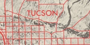
Map of the Month: February 2025
Tombstone is a southeast Arizona town that lies on the historical road between El Paso Texas and San Diego. That critical transportation feature contributed to its importance in the 19th and 20th cent...
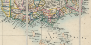
Map of the Month: January 2025
First populated almost 70,000 years ago by Indigenous Australians, Australia is a diverse and beautiful land. Large interior deserts span the majority of the continent, while Eucalyptus forests domina...

Map of the Month: December 2024
Last month, we covered the 49th state in the union. This month, we’re heading to number 50: Hawai’i! This archipelago, an independent unified kingdom from 1810 to 1893, was annexed by the United State...

Map of the Month: September 2024
¡Bienvenidos todos a la Ciudad de México! From the chinampas of Xochimilco to the National Palace in the city center, Mexico City is one of the most historically significant cities of Latin America. W...

Map of the Month: August 2024
The distribution of particular surnames on the island of Ireland lends clues as to the history and movement of its people. Primarily, Irish surnames originate from the Irish language. These names are ...
Map of the Month: July 2024
Project Gemini was the precursor to the famous Apollo program. The main goal of Project Gemini was to support the Apollo program’s main mission: Putting a man on the moon. Developing orbital maneuvers...

Map of the Month: March 2024
The United States National Park Service (NPS) currently administers 63 National Parks and 85 National Monuments, among the astonishing 423 total areas managed by the agency. That scope wasn’t always s...
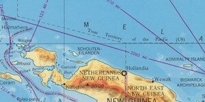
New Web Index: 1959 World Less Polar Regions
A new web map, 1959 World Less Polar Regions, is now live on ASU GeoData. The web map indexes a newly digitized series of maps produced by the Army Map Service in 1959. The maps depict the world at th...