Project Gemini was the precursor to the famous Apollo program. The main goal of Project Gemini was to support the Apollo program’s main mission: Putting a man on the moon. Developing orbital maneuvers to dock with another orbiting spacecraft, demonstrating mission endurance for crewed flight as the trip to the moon would take 8 days and creating methods for spacewalks and other extravehicular activity (like walking on the moon!). Today, we’re going to take a look at a map made from data acquired during one of those Project Gemini missions.
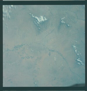
This map is an edit of a photograph taken from orbit on August 21st, during the Gemini V mission in 1965, which was crewed by astronauts L. Gordon Cooper and Charles Conrad Jr. This mission, the fifth one of Project Gemini, marked the first time the U.S. held the record for longest crewed space mission, with Gemini V lasting 8 days. The original image was part of a photography project for the Department of Defense and was taken at an altitude of 100 miles. While the mission was in 1965, this map wouldn’t be published until four years later, in June of 1969. A couple weeks later, Apollo 11 would land on the moon.
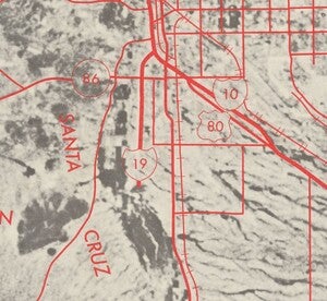
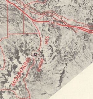
The photograph was then rectified by the Raytheon company to mitigate tilt distortion, with roads and geographic features overlaid on the image by cartographers from the USGS. This gives us a great view on how Tucson has changed. Interstate 19 has only just started and won’t be completed for another 13(!) years. U.S. Route 80, which originally went from Savannah, Georgia to San Diego, California, has since been overtaken by interstate 10. U.S. 80 still exists, though its western terminus is now in Dallas. Any remaining portions of that route are now known as Arizona State Route 80. Numerous other highway and route designations on this map have also been replaced or updated.
Interstate 10 has multiple different AZ state routes converging on it. There’s State Route 84, 93, and 86. These routes are no longer signed along the interstate, though all of these routes still exist with connections to the interstate. State Route 84 has been significantly reduced, nowadays it’s just a 41 mile stretch between I-8 and Casa Grande! The incorrect designation of State Route 83 as 86 has been corrected post-publication with what looks like a sharpie or some other black marker.

The original photograph is actually taken on color film and is oriented very differently. This is likely due to the orbit path and how the camera was mounted. The image, when rectified for the map, was rotated roughly 45 degrees to the right. Why did the USGS choose to print their map in black and white despite the original ‘astronaut’s view’ photograph being in beautiful color? I don’t know, but personally, they should’ve preserved the color. It’s truly beautiful.
We hope you enjoyed our May 2024 Map of the Month! Explore and compare this map to modern-day Tucson in a new interactive web map on ASU GeoData: 1969 Space Age Road Map of Tucson
- Title: “Space Age” Road Map of the Tucson, Arizona Vicinity
- Date: 1969
- Author, USGS, In cooperation with NASA and Raytheon Company
- Publisher: USGS
As with all of our Map of the Month features, if you’d like to learn more about this map or schedule a visit to explore our maps in person, please submit a Map and Geo Service Request. We’ll be sure to get back to you within two business days, but typically sooner.
-Eric Friesenhahn, Map and GIS Specialist


