maps news

Map of the Month: November 2023
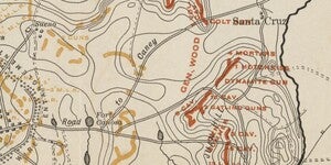
In 1898, Cuba was in the midst of a bloody war for independence from Spain that had been raging for three years. American public opinion swayed dramatically towards support through the 1890s, especially with American journalists fully embracing Yellow Journalism to exaggerate and embellish the atroc...

Map of the Month: October 2023
Salt River Valley, Arizona, 1934. Cartography by T.A. Hayden. In 1934, the Phoenix valley was mostly farmland thanks to the incredibly successful damming of the Salt River with the Roosevelt Dam via the Salt River Project i...

Map of the Month: July 2023
Our July Map of the Month is this 1934 “National Forests, State Forests, National Parks, National Monuments, and Indian Reservations” by the U.S Department of Agriculture and the U.S Forest Service. This historic map acts as a point of reference to compare how much land in the United States has been...

Map of the Month: June 2023
June 6th, 1944. The largest amphibious invasion ever undertaken is in full swing. Our June Map of the Month was published in commemoration of that historic event- known as D-Day. This map was one in a series of maps published throughout the second world war; the “Dated Events War Map”. Ours in parti...

Map of the Month: May 2023
Our May Map of the Month is the 1960 publication, “Geology of the Arctic”, as prepared by the First International Symposium on Arctic Geology. This exquisite map is a compilation of geologic maps, global navigation charts, and bathymetric charts from countries in the northern hemisphere. ...

Seek and Find: creative cartography exhibition at Noble Library
In its ninth year, Noble Library will host the creative cartography exhibition, a collaboration between the ASU School of Art and the ASU Library. The 2022 exhibit, “Seek and Find” is on display at Noble Library on the Tempe campus, from Nov. 16 until Nov. 29 during regular library hours. Visitors c...

ASU Library exhibit celebrates 140-year anniversary of Dutton's Atlas
Oh, people might have read John Wesley Powell’s 1875 book, ultimately titled “The Exploration of the Colorado River and Its Canyons,” but the book wasn’t so much a deep dive into the size, beauty and geology of the Grand Canyon as much as it was a tale of the Wild West. “It was meant to be a geolog...

ASU Library to host 'Dutton's Atlas Symposium: How Cartography Helped the Grand Canyon become Grand'
Celebrate “Dutton’s Atlas,” a masterpiece of early geological inquiry into the Grand Canyon. The public is invited to attend a free symposium presented by the Map and Geospatial Hub at Hayden Library on ASU’s Tempe campus. The event takes place on Saturday, October 22 from 11 a.m. to 4 p.m. ...

Map explorer tool recognized at world's largest GIS conference
Looking for a map but can’t make it to the library? Look no further than your PC or smartphone. The ASU Library Map and Geospatial Hub’s virtual 3D Explorer application opens the doors of the hub to users all over the world, with the ability to experience the space and browse the collection virtual...