¡Bienvenidos todos a la Ciudad de México! From the chinampas of Xochimilco to the National Palace in the city center, Mexico City is one of the most historically significant cities of Latin America. With it being the largest city in the western hemisphere, Mexico City is also one of the most economically and politically important cities in all of Latin America. Moreover, Mexico City is also one of the most important centers of art in the world, with dozens of well known museums like the Museo Nacional de Antropologia, the Frida Kahlo Museum, and the Templo Mayor Museum.
What does this have to do with maps? Well, the feature of our September 2024 Map of the Month is a beautifully drawn map from 1932: Mapa de la Ciudad de México y alrededores, hoy y ayer.

This map offers an impressive blend of function, art, beauty, and history. Along the border of the map one finds 12 different colonial crests for pre-revolutionary Mexico, along with many illustrations and symbols representing the diverse villages of the valley of Anahuac, where Mexico City is located. On the map itself, one can find many of the most iconic places in Mexico City.
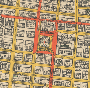
The Plaza de la Constitución, also known as the Zocalo, is the central plaza of the city. In the Zocalo you can find some of the city's most important sites like the Palacio Nacional which houses Mexico’s federal executive branch, the Catedral Metropolitana, the Metropolitan Cathedral and the ruins of the Templo Mayor which was the most important temple in the ancient Aztec city of Tenochtitlan.
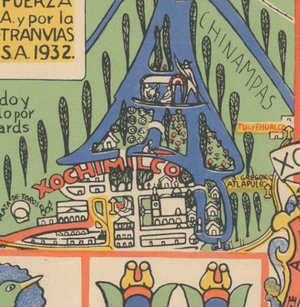
Unfortunately, due to the Spanish conquest of Tenochtitlan, most of the city’s history was lost when the Spaniards built Mexico City; however, there are still some remnants of the old city that still exist to this day. Apart from the ruins of the Templo Mayor, in the image above, we see a magnified portion of the bottom right portion of the map that highlights one of the most important sites in Mexico City: Xochimilco.
Xochimilco holds the last chinampas that remain following Aztec rule over the valley of Mexico. Chinampas were a sophisticated system of artificial islands made by weaving reeds to create basket like structures, and then filling them with dirt, mud and other organic materials to create fertile floating cropland. These were created for agricultural purposes to supply Tenochtitlan with fertile cropland on an otherwise swampy wetland that was not suitable for agriculture or habitation. And not only were these chinampas used for agriculture, but many of the residents of Tenochtitlan would also use them to build homes on, as many of these chinampas were designed so well that they could hold up entire structures.
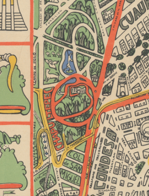
Another one of the most important focal points of Mexico City is the Bosque de Chapultepec, or the Chapultepec Forest. Chapultepec, or Chapoltepec as it was known by the Aztecs, was used as a resting place for the ashes of the rulers of the Aztec Empire, and was considered a very sacred place to the Mexica who were the inhabitants of Tenochtitlan. During the colonial period, Chapultepec was turned into the private forest of the rulers of Mexico, with monuments like the Castle of Chapultepec, the only royal castle in the western hemisphere, being built there. In modern times, the Chapultepec Forest is a public park and serves as the largest ecological space and “lung” for the city’s approximately 22 million inhabitants.
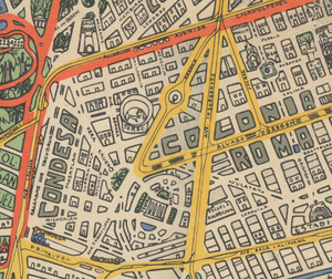
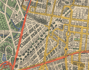
The Colonia Cuauhtemoc, which has the Paseo de la Reforma, one of the most important boulevards in all of Mexico City running through the middle. Today you can find many large office buildings along the Boulevard, and the Angel of Independence, which is one of the city’s most iconic monuments.
Looking more deeply into the map, we find that it was created through a partnership between Mexico City’s utility and transit systems, and served the purpose of displaying the state of Mexico City’s transit system (at that time). Above you can see the central power plant for the city, with the yellow lines displaying the various electrical connections throughout the entire city. Nowadays, it serves as a historical and cultural relic to Mexico, being regarded as one of the most important symbols of post revolutionary Mexico.
We hope you enjoyed our September 2024 Map of the Month!
- Title: Mapa de la Ciudad de México y alrededores, hoy y ayer
- Date: 1932
- Author: Mexican Light & Power Co. LTD. and Mexico Tramways Co
As with all of our Map of the Month features, if you’d like to learn more about this map or schedule a visit to explore our maps in person, please submit a Map and Geo Service Request. We’ll be sure to get back to you within two business days, but typically sooner.
Hasta luego, y feliz mes patrio! ¡Viva México!
-Robert Wickett, Map and GIS Assistant
