map news

Map of the Month: October 2022
Our October Map of the Month is this undated Spanish map titled “Corea y Sur de Mandchuria” (Korea and South Manchuria). It depicts the Korean Peninsula and Southern Manchuria just prior to the start of the Russo-Japanese War, before Japanese occupation and the Division of Korea. It includes various...

Map of the Month: July 2022
Our July Map of the Month is this 1848 “Mexico & Guatemala” map published just before the end of the Mexican-American War by S. Augustus Mitchell. It features a detailed depiction of the various international and state boundaries of Mexico and Central America at the time, many of which were alte...

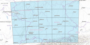
New Map Collection and Index: Southwest Germany to the Alps
The index for our new map series index, Southwest Germany to the Alps, is now available to the public in this interactive web map. The Southwest Germany to the Alps map series index is an interactive web map that displays the topographic features and municipalities of ...

Map of the Month: January 2022
Our January Map of the Month is this 1916 map of “The Theatre of War in Mesopotamia”, displaying Mesopotamia (modern-day Iraq and Syria) and Persia (modern-day Iran) as they appeared in the midst of World War I. This map was published in Edward Stanford’s War Map No. 9 and includes an inset of “The...

Map of the Month: December 2021
Our December Map of the Month is this French map titled “New Mexico, with the Northern Part of Old, Or New Spain”. Among the oldest maps in our collection, this map was made by Rigobert Bonne and was published in 1780 as part of Guillaume-Thomas Raynal’s famous Atlas de Toutes Les Parties Connues du...

Map of the Month: November 2021
Our November Map of the Month is this illustrated map titled “Grand Canyon” by Uruguayan-American artist Jo Mora. The map depicts approximately one fourth of the Grand Canyon, focusing on the portion most frequented by tourists. It features a variety of insets and illustrations highlighting the main...

Map of the Month: October 2021
Our October Map of the Month is this 1963 map titled “Arizona’s Lost Mines and Ghost Towns”. It features some of Arizona’s most famous lost mines and ghost towns as well as the more obscure, and it includes many illustrations related to Arizona’s history and the “Wild West” era that these towns and ...

Map of the Month: September 2021
It’s been one month since Sun Devils came back to campus after nearly 16 months of remote learning. To celebrate our return to in-person learning, our September Map of the Month is this 1980 illustrated map of Tempe, Arizona. It highlights many of Tempe’s community landmarks and provides a look at j...

Map of the Month: July 2021
Our July Map of the Month is this 1967 Soviet lunar map from the series titled Polnaya Karta Luny Complete Map of the Moon. The series is made up of nine sheets that display several magnified lunar quadrant maps, translations of the labels throughout the series, and this final composite lunar pole m...