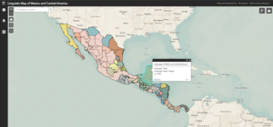
Our latest web app, Linguistic Map of Mexico and Central America, is now live and available to the public.
- Geographic Coverage: Mexico, Guatemala, Belize, El Salvador, Honduras, Nicaragua, Costa Rica, Panama
- Date: 1909
- Scale: ~1:6,991,448
- Physical Availability: in-house only
- Digital Availability: scanned (600 DPI)
Unlike our other web map indexes, this web app features one intricate 1909 Linguistic Map of Mexico and Central America. This historic map depicts over 90 Indigenous languages throughout the entirety of Mexico and Central America. It was created to document the location and span of as many Indigenous languages as the project surveyors could pinpoint.
The features of this app highlight the complexity of this map and make it easier for viewers to interpret the map's wealth of data. Each polygon is selectable and paired with a pop-up box that includes information on the area's specific language and language family. Each polygon matches the coloring of the original map as seen in the map’s legend. A scan of the physical map is also available to view alongside the digital version in the app.
This map provides modern linguists and anthropologists with unique insight into the historic distribution of Indigenous languages throughout Mexico and Central America, including the location and relative size of languages that are now classified as extinct or endangered, such as Matagalpan and Pakawan (extinct) and Lencan (endangered).
We hope you enjoy exploring the array of Inidgenous linguistic data available in our newest web app! If you would like to request a high-resolution scan of the original 1909 map or would like to schedule an appointment to explore the collection in person, please submit a Service Request to the Map and Geospatial Hub. Be sure to follow our Facebook page for the latest Map and Geospatial Hub updates!
-Kelsey Kerley, Map and GIS Assistant

