Our August Map of the Month is this 1964 reproduction of a 1764 map titled “Plan de la Nouvelle Orleans”. It depicts the land that now makes up New Orleans' French Quarter as it existed over 250 years ago, just before Louisiana was ceded to Spain. It includes a legend marking places of interest such as religious facilities, housing of enslaved peoples, tradesmen workspaces, and more.
Originally published in Jacques-Nicolas Bellin’s 1764 “Petit Atlas Maritime”, “Plan de la Nouvelle Orleans” is one of the earliest maps of New Orleans. One of the most significant details highlighted in this map is the neat grid system used to organize the city. This grid system was formally established in 1722 after a hurricane decimated most of the city’s buildings, leading its residents to rebuild according to the grid system that still exists in the French Quarter today. In addition to its representation of this historic grid system, the detailed legend at the top of this map features a variety of buildings and institutions that were likely very prominent in the community and are therefore significant in modern historical study.
The legend of this map indicates that there were multiple well-established religious orders in New Orleans at this time, most notably the Capuchin friars and the Ursuline nuns. Although both orders are affiliated with the Catholic Church, their missions differ slightly: Ursulines dedicate themselves to educating young girls and providing care to the sick, while Capuchins dedicate themselves to preaching and caring for the poor. This map shows how their differing missions led to differing roles in the community, as the central church of the city is marked as the parish served by the Capuchins (marked by letter A on map). The Capuchin convent (C) as well as the city jail (D) are located next to this church, and while this close proximity of the jail to the church may seem odd, Capuchin friars have often served as ministers in jails and prisons throughout history. On the other hand, the Ursulines convent (S) is located at the edge of the city across the street from the hospital, likely to provide quick access to assist in caring for the sick and injured people who resided there. This convent still stands in New Orleans and is one of, if not the oldest building in the City. The building is now the Old Ursuline Convent Museum, and is open to the public.

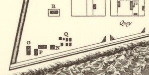
This map also provides information about where some people from different classes lived and worked. One example is the map's lower left quadrant that depicts the huts where enslaved people lived (Q) next to the windmill (N) where they likely worked. Right next to this are a guardhouse as well as the naval hangar, indicating that there was a rather large military presence adjacent to the homes of slaves, perhaps to maintain control over the enslaved people. All of these buildings are located at the city’s edge, evidencing both that enslaved people were not permitted to live among non-enslaved people and also that France took advantage of the city’s position on the Mississippi River to establish a naval base on the American continent.
There are also several indications of the influence and presence of the King of France’s power in New Orleans at this time, such as buildings like the king’s forges (M) and the king’s magazines/press (K), where pamphlets and other materials would have been printed in the king’s name. These institutions likely maintained French standards of metalworking and printing trades in New Orleans despite the city’s physical distance from France. The press in particular would have played a large role in dispersing news about the French monarchy and the nation’s situation as well as in the production of political propaganda.
Although the influence of the French government in New Orleans was abundant at the time of this map’s creation, by 1769 the territory was firmly under Spanish control after France ceded it to the Spanish Empire at the end of the Seven Years War. Despite the territory’s return to French rule about 30 years later, Spanish influence on New Orleans was vast, and much of the iconic architecture of the city in the present day are actually remnants of Spanish rule rather than French. However, Spanish rule did not override the city’s French roots that still ensue in the present, creating a multifaceted culture and city that are unique in the American South.
We hope you enjoyed this month's map! As with all of our Map of the Month features, if you’d like to learn more about this map or schedule a visit to explore our maps in person, please submit a Map and Geo Service Request. We’ll be sure to get back to you within two business days, but typically sooner.
-Kelsey Kerley, Map and GIS Assistant


