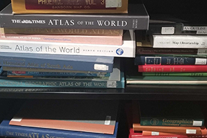
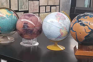
Tens of thousands of maps and related cartographic materials -- such as atlases, globes, and books on cartography -- are available through the ASU Library Map and Geospatial Hub.
Maps

3D Explorer
Use the 3D Explorer application to browse our collections of maps and related cartographic materials. The Map and Geospatial Hub stewards approximately 50,000 maps (excluding aerial photographs) from across the world. The bulk of our maps pertain to the lands and people throughout the state of Arizona, with particular focus on the greater Phoenix region. Collection strengths extend to the greater American Southwest and northwestern Mexico, but include all regions of the Earth. You can use keywords for simple map searches, or apply additional filters using the advanced search function. The 3D Explorer will identify and visualize the location of the item(s) you're looking for, and provide item-level details, including options for in-person or digital access (when available).

Geologic maps
We hold geologic maps from USGS, AAGS, and the Arizona Geological Survey, as well as from various other sources covering other US states and countries.
Outside Resources:
Historic maps

Sanborn Fire Insurance Maps
- Sanborn Index: Arizona Cities 1883-1948
- Digital Availability: Digital Sanborn Maps AZ Database (for ASU affiliates)
- Outside Resources: Library of Congress Sanborn Maps
- Guide: Description and Utilization of The Sanborn Map

Other historic map sources
- Arizona Memory Project
- Arizona National Forest Map 1907-1945
- Gila County Maps
- Historic Arizona County Road Maps
- Maricopa County Land Ownership Maps 1903-1929
- Sharlot Hall Museum Map Collection
- Atchison, Topeka & Santa Fe Railway Company (Albq Division) Collection
- Robert Lenon Map Collection
- OldMapsOnline
- David Rumsey Map Collection
- The Perry-Castañeda Library Map Collection
- The Library of Congress

Arizona topographic maps
The AZ USGS 1:24k Topo Maps web app displays the geographic extent of the USGS 1:24,000 quandrangles to aid in identifying and requesting topographic maps from the ASU Library Map and Geospatial Hub.
- Geographic Coverage: AZ USGS 1:24k Topo Maps Index
- Time Range: 1893-2010
- Cartographic Scale: 1:24,000
- Physical Availability: in-house use only
- Digital Availability: see topoView

United States topographic maps
Outside resources:

Mexico topographic maps
1:1,000,000, 1:250,000, 1:50,000, and 1:20,000 topographic maps and related data, downloadable in multiple formats (shp, PDF, gif, tiff, GeoPDF).
Outside resources: INEGI
Other cartographic materials

Atlases, cartography and GIS books
A range of atlases and books on cartography are available. These publications cover the art, science, history, and methods of mapmaking from world to regional coverage are in the Map and Geospatial Hub and other ASU Library locations; they can be found through a quick library catalog search.

Globes
Several globes are available for in-room study, including spherical scaled models of the Earth (including Earth's plate tectonics), the Moon, and Mars.

Federal Depository Library Program
ASU Library is a Federal Depository Library. We maintain a collection of current maps produced by US government agencies. Click on the link above to learn more.