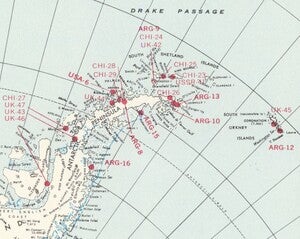
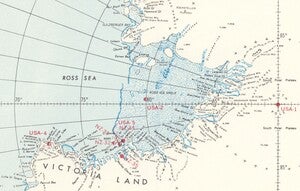
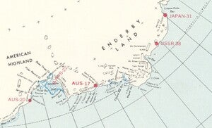
Our December Map of the Month is this 1970 map of Antarctica area stations that was prepared for the 1969 expedition of the U.S. Navy Operation Deep Freeze called “Deep Freeze 70”. It is a complete map of the Antarctic continent that features extensive detail on the locations of all operating and recently deactivated research stations that had been established by the beginning of this Operation Deep Freeze mission.
Operation Deep Freeze was a series of scientific missions to Antarctica that were supported by the United States Navy. The first mission took place from 1955-56 and the U.S. continued sending missions under the title of Operation Deep Freeze through 1998. These missions were sparked largely by the increasing global interest in Antarctica that developed after the Second World War. It marked the beginning of an era of increased research into the continent as well as a blend of international competition and collaboration as nations jockeyed for research space while simultaneously working through the turmoil of the Cold War to allow for scientific research to occur freely.
Although Antarctic explorations had been ongoing to some degree since the 1800s, after the “Heroic Age” of Antarctic exploration ended in 1922 there was a lapse in study of the continent. An attempt to reignite interest was made with the Second International Polar Year in 1932, and while that endeavor did successfully result in the research collaboration of over 40 countries, the financial hardships of the Great Depression prevented many new research plans from being executed and the Second World War resulted in much of the research data being lost. However, once the war ended, many nations were left with no place to direct the vast technological advancements they made during the war, which led them again to focus on Antarctica. The lingering post-war tensions, particularly between U.K. - Argentina (given its sympathy toward Germany) and U.S. - U.S.S.R., contributed to an interest in establishing claims to Antarctic land. The 1950s saw several nations make claims to establish research and data collection stations, all of which are documented on this map.
One area of particularly high station concentration is the Antarctic Peninsula. There are 17 stations located on the Peninsula and its surrounding islands, all of which are evidence of the attempts of several nations (particularly Argentina, Chile, and the U.K.) to lay claim to research areas on one of the more accessible areas of the continent. While the neighboring research stations and competition for space may seem like a foundation for tense international relations on the continent, they instead helped create a culture of cooperation among Antarctic scientists from around the world. The surge of research led to the establishment of a Third International Polar Year (also called the International Geophysical Year) in 1957, which notably re-initiated some scientific exchange between the Eastern and Western hemispheres. The success of this cooperation inspired the Antarctic Treaty System, a treaty ratified in 1961 by the 12 countries that participated in the International Geophysical Year to officially dedicate Antarctica as a scientific preserve. This treaty system still protects Antarctica and has 55 signatories as of 2022.
The American research stations on this map are generally more evenly distributed than those of several other nations. Unlike the multiple Chilean and Argentinian stations on the Antarctic Peninsula, the only American research station located on the peninsula on this map is Palmer station, which was originally constructed in 1968 and is the third oldest American Antarctic research base that is still active today. The other American stations depicted on this map are dotted throughout the open tundra of the continent, the coastal territory bordering the Ross Sea, and most conspicuously on the South Pole itself. This South Pole station is the Amundsen-Scott South Pole Station, another of the United States’ oldest Antarctic research bases that is still operational decades after its construction in 1956. It was the first permanent structure built at the pole and was one of the earliest interior Antarctic research stations established by any nation. The unique location of this station has long allowed its researchers to study a variety of subjects, from geophysics and meteorology to biomedicine and astrophysics.
Operation Deep Freeze was one of dozens of international missions and expeditions to increase the existing research facilities and scientific endeavors on Antarctica throughout the second half of the 20th century. The work done throughout the series of expeditions that fell under the title contributed to a great advancement in global scientific knowledge, from developing American knowledge about space during the Space Race to modern applications regarding climate change and rising sea levels. Today, there are roughly 70 operating research bases on the continent, the majority of which were constructed after this map's publication to continue advancing scientific research in Antarctica.
We hope you enjoyed this month's map, and hope you look forward to next year's maps! As with all of our Map of the Month features, if you’d like to learn more about this map, get a scan of this map, or schedule a visit to explore our maps in person, please submit a Map and Geo Service Request. We’ll be sure to get back to you within two business days, but typically sooner.
- Kelsey Kerley, Map and GIS Assistant


